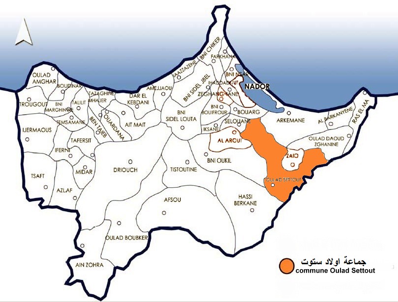
جماعة اولاد ستوت Commune Oulad Settout
In the Oriental region
The OpenStreetMap settlement record identifies Oulad Settout; its mapped point falls within the checked Oriental regional boundary.
Plan around your destination
Use the Oriental travel guide for the complete destination directory. The Nador travel guide connects coastal and city visits with onward road information. See the named places and trip ideas below to choose a stop that fits your route.
Oulad Settout is a mapped settlement in Morocco’s Oriental region. Explore its location with the surrounding destination and road guides before choosing where to stop.
モロッコの地
土地を読む
- 町または市
- Oulad Settout
- 地方
- Oriental
Mapped places around the destination use a 20 km geographic area. Use the road-distance filter in Explore to check your approach.
Nature and outdoors
Outdoor places around this destination. Showing 6 selected places.
- Azrou Ouzayou
Azrou Ouzayou is recorded as a mountain peak in Nador.
- Jbel Aklim Alkabir جبل اكليم الكبير
Jbel Aklim Alkabir جبل اكليم الكبير is recorded as a mountain peak in Berkane.
- jbel aklim sghir جبل اكليم الصغير
jbel aklim sghir جبل اكليم الصغير is recorded as a mountain peak in Berkane.
- Jbel Bou Iassamdane جبل بويصامدن
Jbel Bou Iassamdane جبل بويصامدن is recorded as a mountain peak in Nador.
- Jbel sabato rijal جبل سبعة رجال
Jbel sabato rijal جبل سبعة رجال is recorded as a mountain peak in Nador.
- Jbel Thekabbatte جبل ثقباط
Jbel Thekabbatte جبل ثقباط is recorded as a mountain peak in Nador.
Places to stay
Named accommodation. Confirm facilities and availability directly with the host.
Stay & arrange your visit
Explore accommodation around Oulad Settout or review services offered by local providers. A place in the guide does not imply available rooms or a partnership.
地図上
認証済みの地元の方が提供
関連付けられたパートナー提供はまだありません。
Browse local services in Oriental